Case Study_02

ICPAC Website Migration.

A full Next.js migration for the IGAD Climate Prediction and Applications Centre — modernising content delivery, integrating live geospatial map layers, and cutting load time by 45%.

ROLE

Full Stack Engineer, Independent Contractor

TIMELINE

Sep 2024 - Jan 2025

0%

Page Load Time Reduction

0→

Lighthouse Score

0%

Codebase Complexity Reduction

Geospatial Map Architecture

Climate map data is served from a MapServer instance exposing OGC-compliant WMS endpoints. On the Next.js side, maps are rendered client-side using Leaflet.js — imported via next/dynamic with { ssr: false } to prevent hydration errors from Leaflet's browser-only APIs. WMS tile layers stream directly from MapServer into the Leaflet canvas, keeping the React layer thin and avoiding expensive server-side GeoJSON serialisation. PostGIS powers the underlying spatial queries, with indexed geometry columns enabling fast bounding-box lookups across IGAD's regional climate datasets.

Next.jsTypeScriptLeaflet.jsMapServerPostGISWMS
ICPAC geospatial architecture: MapServer WMS → Next.js dynamic import → Leaflet.js

FIGURE B.01

MapServer WMS → Leaflet.js Rendering Pipeline

Engineering Challenges.

01

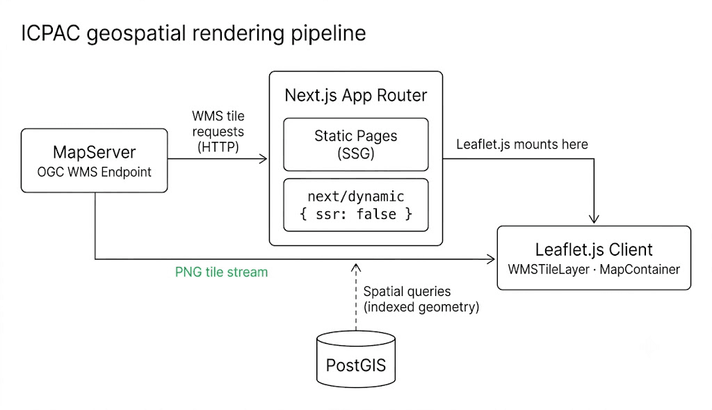
Leaflet directly accesses window and document on import — crashing Next.js's server render and throwing hydration mismatches on the client.

Solution

Wrapped the map component in next/dynamic with { ssr: false }, isolating all Leaflet instantiation to the browser. This eliminated the crash entirely while keeping the rest of the page statically generated.

02

MapServer tile responses were slow on low-bandwidth connections, causing visible map lag for users in the IGAD region.

Solution

Configured Leaflet's TileLayer.WMS with explicit bounds, min/max zoom, and attribution. Added cache-control headers on the MapServer proxy to serve repeat tile requests from edge cache rather than re-querying PostGIS.

Integrating geospatial tooling into a modern React stack surfaces browser/server boundaries fast — and rewards upfront discipline in how map state is owned.

Dynamic Imports Are Not Optional

Any library touching browser globals must be isolated behind next/dynamic — attempting workarounds wastes time and introduces subtle bugs.

WMS First, GeoJSON Second

Streaming tiles from MapServer was far cheaper than hydrating full GeoJSON on the client — the right tool for regional climate overlays at this scale.

Measure Before Migrating

Baseline Lighthouse audits before a single line was changed made it clear exactly where the 45% load gain would come from.

Accessibility Is Non-Negotiable

Fixing contrast and semantic markup was one of the quickest wins — and immediately expanded reach for a platform with a global, multilingual audience.

ClimateMap.tsx

Brian Mutai / Full Stack Engineer